Analysis of creep on the North Anatolian Fault at Ismetpasa using InSAR
Prof. Tim Wright, Ekbal Hussain, Prof. Andy Hooper and Dr Richard Walters
The North Anatolian Fault Zone (NAFZ) is a major continental strike-slip fault system, comparable in length and slip rate to the San Andreas Fault Zone (Figure 1). It crosses a densely populated region of northern Turkey and constitutes a major seismic hazard. Over 1000 km of the NAFZ ruptured during 12 M≥6.7 earthquakes in the 20th century (Barka 1996). Despite its length, the NAFZ is a relatively simple structure, with most of the deformation being concentrated on a single fault strand (Meade, Hager et al. 2002). The western end of the NAFZ ruptured in two major earthquakes in 1999 at Izmit on 17 August (M7.5) and Düzce, 87 days later (M7.2), in which more than 30,000 people lost their lives. These earthquakes were both recorded extremely well by seismology and satellite geodesy (InSAR and GPS), and the co-seismic source models have been accurately determined (Wright, Fielding et al. 2001; Burgmann, Ayhan et al. 2002). A seismic gap remains south of Istanbul, an urban centre of more than 10 million people, where there is ~60% chance of significant shaking within the next few decades (Parsons, Toda et al. 2000).
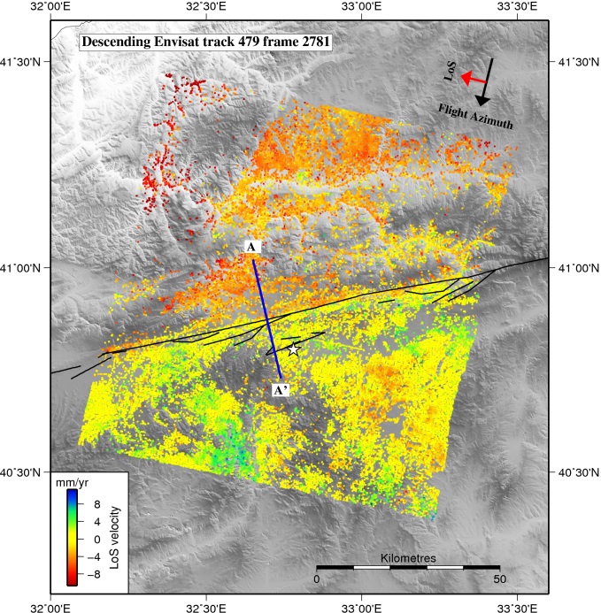
The portion of the North Anatolian fault at Ismetpasa has previously been identified as a location where shallow creep is ongoing (e.g. Cakir, Akoglu et al. 2005; Kaneko, Fialko et al. 2013). We have conducted a preliminary InSAR deformation analysis of data from the ERS and Envisat satellites spanning the period 1992 to 2010, and this confirms that creep is localised on the fault at Ismetpasa. Recently, it has been proposed that the creep is episodic and not steady in time. The aim of this project is to analyse the radar deformation data from Turkey to determine if the creep is steady in time or episodic. The student will achieve this by careful examination of the InSAR time series, and individual interferograms covering the area.
The project will introduce the student to the acquisition, processing, and analysis of satellite radar data for use in active tectonics. The results will provide important insights into the mechanics of faulting and the behaviour of a major tectonic fault, and they will have implications for ongoing seismic hazard in the region. It links closely to the major NERC-funded FaultLab project, which has used seismology, field investigations, geodesy and modelling to investigate the mechanics of faulting in Turkey.
Figure: Map showing surface velocities measured with satellite radar interferometry across the North Anatolian Fault. Note the sharp colour change across the fault, which indicates that there is creep at the surface.


